Towards an Atlas of Nuragic Sardinia
Access to the map and a structure of concepts/terms for orientation.
Atlas and Artificial Intelligence
For over 3,500 years Nuragic monuments have deeply shaped the landscape of Sardinia. Understanding how many they are, where they are located and which risks they face represents today a major scientific, cultural and territorial challenge. The Association La Sardegna verso l’Unesco has been working for years to address these questions, contributing to the construction of the Atlas of the monuments of the Nuragic civilization as a unified tool for knowledge, protection and enhancement. In this process the Association is a partner of the DICAAR of the University of Cagliari within the RETURN project, a PNRR initiative that in Sardinia considers Nuragic monuments as a model of resilience to climate change. From this collaboration the geoportal NuragicReturn – Towards an Atlas of Nuragic Sardinia was created, dedicated to the systematic survey of sites and aimed at assessing the risks to which they are exposed. The geoportal represents an unprecedented synthesis that integrates and harmonizes numerous existing mappings and information bases – from the National Geoportal of Archaeology to regional catalogues and research projects – reaching more than ten thousand sites. The final goal is the realization of an Atlas built on shared methodological bases, with unified scientific purposes, developed in collaboration with Sardinian universities, the Ministry of Culture and the Autonomous Region of Sardinia. The project, already initiated with researchers from the DUMAS Department of the University of Sassari and the LETTLIB Department of the University of Cagliari, foresees the experimentation of a new method for cataloguing Nuragic heritage, designed to respond to its specificity, complexity and territorial articulation. In this perspective, the Atlas is not only a consultation tool but a true data infrastructure. Its mission is to provide communities, research and institutions with an ordered, verifiable and shared information base on the Nuragic civilization, according to the principles of Public Archaeology. It is within this framework that the Atlas assumes a central role for the future development of artificial intelligence models. The geolocated database of Nuragic monuments, structured according to coherent scientific criteria, represents the fundamental prerequisite for the application of the most advanced technologies in digital archaeology.
What it is
A gateway to data and mappings, with a minimal vocabulary to clarify the organization of evidence (sites, complexes, monuments) and typologies. Within AI Archeo-HUB, the Atlas can support artificial intelligence models dedicated to the automatic classification of artifacts, virtual reconstruction of architectural structures, prediction of potential archaeological sites and analysis of environmental risks. Inventory and cataloguing activities may also benefit from automated procedures based on remote sensing, machine learning and spatial analysis, progressively improving data quality, updating and interoperability. In this sense, the Atlas of the monuments of the Nuragic civilization acts as a bridge between archaeology, territory and artificial intelligence: a dynamic device capable of evolving over time and supporting new forms of research, interdisciplinary training and community engagement.
Map preview
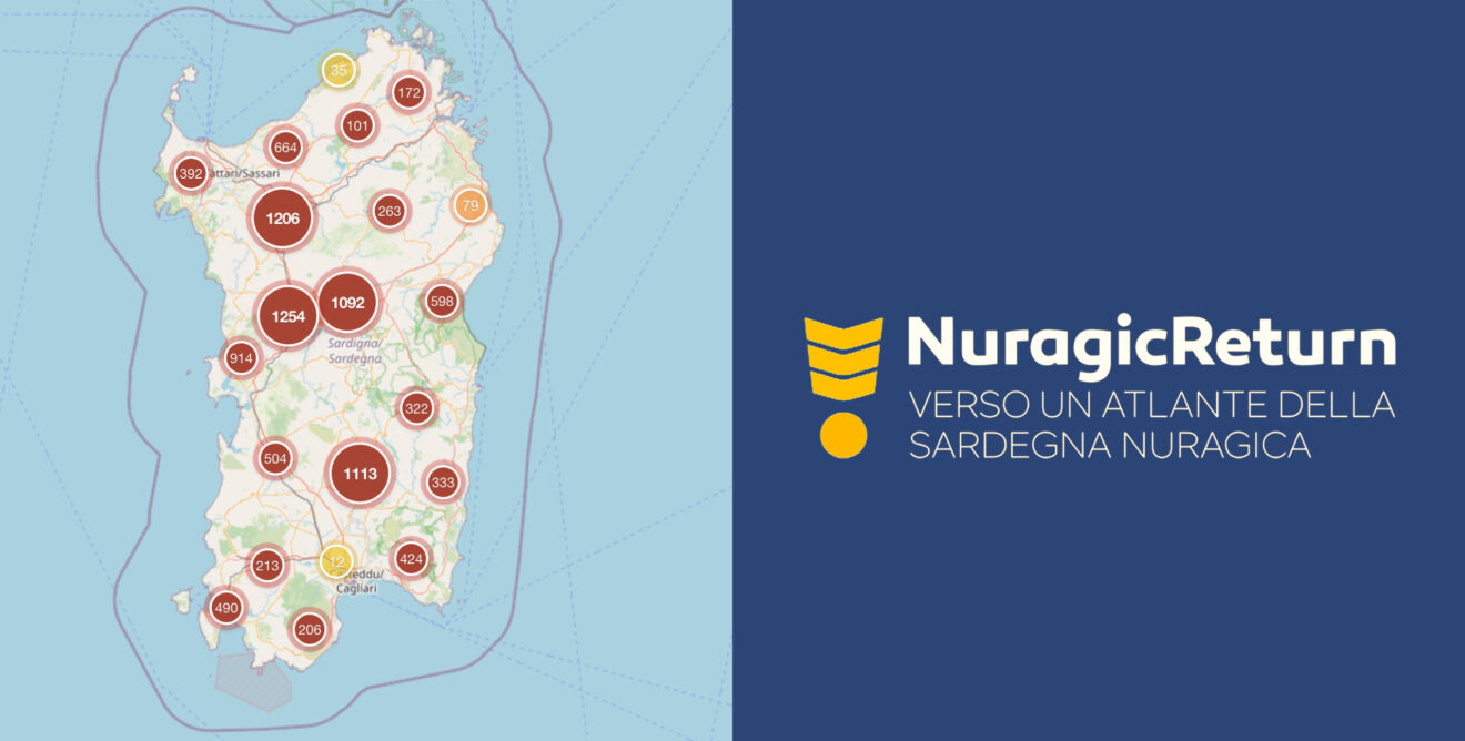
Preview of the NuragicReturn geoportal. Click the image to open it at full resolution.
Definitions
Short operational glossary: levels (assets) and classes (types).
Assets
- Site
- Portion of territory with archaeological evidence (visible or buried).
- Complex
- Coherent set of archaeological elements within a site.
- Monument
- Described and classified unit (linked to sites and complexes).
Types
Proto-nuraghe
Early buildings with corridors/terraces preceding chambered nuraghi.
Nuraghe
Single tower with circular plan and internal chamber, often with staircase.
Complex nuraghe
Main tower with additional bastions or towers (bilobed, trilobed, etc.).
Giants’ Tomb
Funerary structures with different architectural solutions.
Sacred wells and springs
Water-related architectures often interpreted as ritual spaces.
Settlements
Habitational structures sometimes connected to a nuraghe or a complex.
Institutional partners
